മിന്നീപോളിസ്
മിന്നീപോളിസ് (/ˌmɪniˈæpəlɪs/ ⓘ) അമേരിക്കൻ ഐക്യനാടുകളിലെ മിനസോട്ട സംസ്ഥാനത്തെ ഹെന്നെപിൻ കൌണ്ടിയിലെ [5] കൌണ്ടി ആസ്ഥാനവും മിന്നീപോളിസ്-സെന്റ് പോൾ ഇരട്ടനഗരങ്ങളിലെ വലുതും അമേരിക്കൻ ഐക്യനാടുകളിലെ പതിനാറാമത്തെ വലിയ മെട്രോപോളിറ്റൻ മേഖലയുമാണ്. 2016 വരെയുള്ള ജനസംഖ്യാ കണക്കുകളനുസരിച്ച്, മിനസോട്ട സംസ്ഥാനത്തെ ഏറ്റവും വലിയ നഗരമാണ് മിന്നീപോളിസ്. 413,651 ജനസംഖ്യയുള്ള ഇത് അമേരിക്കൻ ഐക്യനാടുകളിലെ 46 ആമത്തെ വലിയ നഗരവുമാണ്. 3.5 മില്ല്യൺ ജനങ്ങൾ അധിവസിക്കുന്ന ഈ ഇരട്ടനഗര മെട്രോപോളിറ്റൻ മേഖലയ്ക്ക്, മദ്ധ്യപടിഞ്ഞാറൻ പ്രദേശത്ത് മൂന്നാം സ്ഥാനമുണ്ട്. മിന്നീപോളിസു സെന്റ് പോളും ചേർന്ന് ചിക്കാഗോ കഴിഞ്ഞാൽ മദ്ധ്യപടിഞ്ഞാറൻ പ്രദേശത്തെ രണ്ടാമത്തെ ഏറ്റവും വലിയ സാമ്പത്തിക കേന്ദ്രം രൂപം കൊള്ളുന്നു.[6]
മിന്നീപോളിസ്, മിനസോട്ട | |||||
|---|---|---|---|---|---|
| City of Minneapolis | |||||
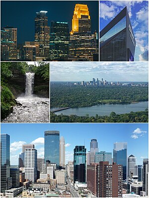
 Clockwise from top left: Downtown Minneapolis at night, U.S. Bank Stadium, the skyline from Lake Nokomis, Minneapolis skyline and Minnehaha Falls | |||||
| |||||
| ശബ്ദോത്പത്തി: Dakota word mni (water) with Greek polis (city) | |||||
| Nickname(s): "City of Lakes", "Mill City", "Twin Cities" (a nickname shared with Saint Paul), "Mini Apple" | |||||
| Motto(s): En Avant (French: 'Forward') | |||||
 Location in Hennepin County and the U.S. state of Minnesota | |||||
| Coordinates: 44°59′N 93°16′W / 44.983°N 93.267°W | |||||
| Country | United States | ||||
| State | Minnesota | ||||
| County | Hennepin | ||||
| Incorporated | 1867 | ||||
| സ്ഥാപകൻ | John H. Stevens and Franklin Steele | ||||
| • ഭരണസമിതി | Minneapolis City Council | ||||
| • Mayor | Betsy Hodges (DFL) | ||||
| • City | 58.4 ച മൈ (151.3 ച.കി.മീ.) | ||||
| • ഭൂമി | 54.9 ച മൈ (142.2 ച.കി.മീ.) | ||||
| • ജലം | 3.5 ച മൈ (9.1 ച.കി.മീ.) | ||||
| ഉയരം | 830 അടി (264 മീ) | ||||
| • City | 3,82,578 | ||||
| • കണക്ക് (2016)[3] | 4,13,651 | ||||
| • റാങ്ക് | US: 46th MN: 1st | ||||
| • ജനസാന്ദ്രത | 7,660/ച മൈ (2,959/ച.കി.മീ.) | ||||
| • മെട്രോപ്രദേശം | 35,51,036 (US: 16th)[1] | ||||
| • CSA | 41,97,883 (US: 14th) | ||||
| Demonym(s) | Minneapolitan | ||||
| സമയമേഖല | UTC−6 (CST) | ||||
| • Summer (DST) | UTC−5 (CDT) | ||||
| ZIP codes | 55401 – 55488 (range includes some zip codes which are for Minneapolis suburbs) | ||||
| ഏരിയ കോഡ് | 612 | ||||
| FIPS code | 27-43000 | ||||
| GNIS feature ID | 0655030[4] | ||||
| വെബ്സൈറ്റ് | www | ||||
അവലംബം
തിരുത്തുക- ↑ "Table 1. Annual Estimates of the Population of Metropolitan and Micropolitan Statistical Areas: April 1, 2010 to July 1, 2016" (CSV). 2016 Population Estimates. United States Census Bureau, Population Division. March 2016. Retrieved June 27, 2017.[പ്രവർത്തിക്കാത്ത കണ്ണി]
- ↑ "Metropolitan and Micropolitan Statistical Areas". United States Census Bureau, Population Division. മേയ് 19, 2016. Archived from the original on May 18, 2016. Retrieved May 19, 2016.
- ↑ ഉദ്ധരിച്ചതിൽ പിഴവ്: അസാധുവായ
<ref>ടാഗ്;USCensusEst2016എന്ന പേരിലെ അവലംബങ്ങൾക്ക് എഴുത്തൊന്നും നൽകിയിട്ടില്ല. - ↑ "US Board on Geographic Names". United States Geological Survey. October 25, 2007. Retrieved January 31, 2008.
- ↑ "NACo County Explorer". National Association of Counties. Retrieved January 23, 2016.
- ↑ Gullickson, Ryan. "U.S. Metro Economies" (PDF). IHS Global Insight. IHS Global Insight. Archived from the original (PDF) on March 5, 2015. Retrieved February 1, 2015.


