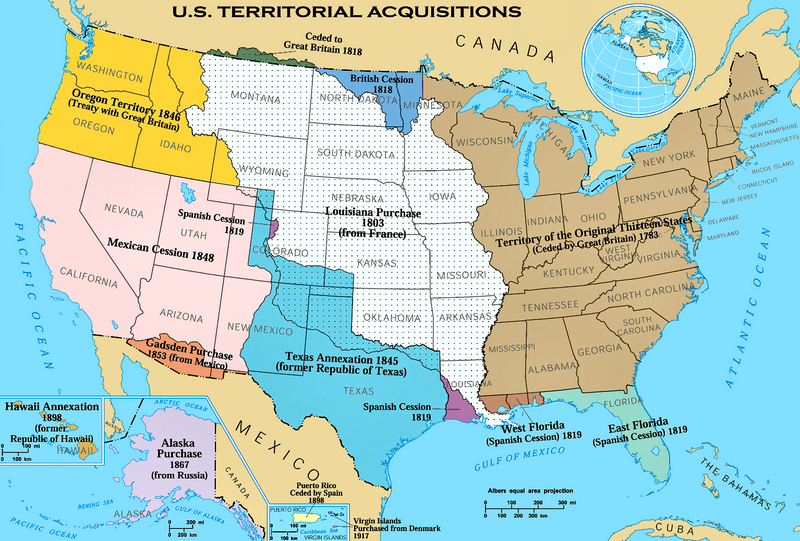
പ്രമാണം:U.S. Territorial Acquisitions.png

ഈ പ്രിവ്യൂവിന്റെ വലിപ്പം: 800 × 541 പിക്സലുകൾ. മറ്റ് റെസലൂഷനുകൾ: 320 × 216 പിക്സലുകൾ | 640 × 433 പിക്സലുകൾ | 1,024 × 692 പിക്സലുകൾ | 1,280 × 865 പിക്സലുകൾ | 1,536 × 1,038 പിക്സലുകൾ.
പൂർണ്ണ വലിപ്പം (1,536 × 1,038 പിക്സൽ, പ്രമാണത്തിന്റെ വലിപ്പം: 1.11 എം.ബി., മൈം തരം: image/png)
പ്രമാണ നാൾവഴി
ഏതെങ്കിലും തീയതി/സമയ കണ്ണിയിൽ ഞെക്കിയാൽ പ്രസ്തുതസമയത്ത് ഈ പ്രമാണം എങ്ങനെയായിരുന്നു എന്നു കാണാം.
| തീയതി/സമയം | ലഘുചിത്രം | അളവുകൾ | ഉപയോക്താവ് | അഭിപ്രായം | |
|---|---|---|---|---|---|
| നിലവിലുള്ളത് | 07:43, 6 ഡിസംബർ 2020 |  | 1,536 × 1,038 (1.11 എം.ബി.) | Petri Krohn | Reverted to original high-resolution version. If you have issues with terminology of the British Isles, at least keep the resolution of the map. |
| 01:52, 10 ജനുവരി 2016 |  | 922 × 623 (574 കെ.ബി.) | Elevatorrailfan | The United Kingdom came into existence in 1801. | |
| 02:22, 16 ഏപ്രിൽ 2013 |  | 1,536 × 1,038 (1.11 എം.ബി.) | Futurist110 | Reverted to version as of 17:56, 13 June 2012 | |
| 23:55, 15 ഏപ്രിൽ 2013 |  | 3,300 × 2,550 (702 കെ.ബി.) | Futurist110 | Higher resolution. | |
| 17:56, 13 ജൂൺ 2012 |  | 1,536 × 1,038 (1.11 എം.ബി.) | Phoenix B 1of3 | Reverted to version as of 15:36, 16 September 2006 Undoing own revision per talk page | |
| 17:26, 13 ജൂൺ 2012 |  | 1,536 × 1,038 (1.12 എം.ബി.) | Phoenix B 1of3 | color puerto rico to differentiate it from mexico and cuba. | |
| 15:36, 16 സെപ്റ്റംബർ 2006 |  | 1,536 × 1,038 (1.11 എം.ബി.) | Shizhao | {{Information| |Description= United States Territorial Acquisitions == Summary == {{main|United States territorial acquisitions}} This image depicts the United States' historic acquisitions of territories, such as the Thirteen Colonies, the Louisiana Pur |
പ്രമാണത്തിന്റെ ഉപയോഗം
താഴെ കാണുന്ന താളിൽ ഈ ചിത്രം ഉപയോഗിക്കുന്നു:
പ്രമാണത്തിന്റെ ആഗോള ഉപയോഗം
താഴെ കൊടുത്തിരിക്കുന്ന മറ്റ് വിക്കികൾ ഈ പ്രമാണം ഉപയോഗിക്കുന്നു:
- af.wiki.x.io സംരംഭത്തിലെ ഉപയോഗം
- am.wiki.x.io സംരംഭത്തിലെ ഉപയോഗം
- ar.wiki.x.io സംരംഭത്തിലെ ഉപയോഗം
- arz.wiki.x.io സംരംഭത്തിലെ ഉപയോഗം
- ast.wiki.x.io സംരംഭത്തിലെ ഉപയോഗം
- az.wiki.x.io സംരംഭത്തിലെ ഉപയോഗം
- bg.wiki.x.io സംരംഭത്തിലെ ഉപയോഗം
- bn.wiki.x.io സംരംഭത്തിലെ ഉപയോഗം
- ca.wiki.x.io സംരംഭത്തിലെ ഉപയോഗം
- ckb.wiki.x.io സംരംഭത്തിലെ ഉപയോഗം
- cs.wiki.x.io സംരംഭത്തിലെ ഉപയോഗം
- da.wiki.x.io സംരംഭത്തിലെ ഉപയോഗം
- de.wiki.x.io സംരംഭത്തിലെ ഉപയോഗം
- de.wikiversity.org സംരംഭത്തിലെ ഉപയോഗം
- dtp.wiki.x.io സംരംഭത്തിലെ ഉപയോഗം
- el.wiki.x.io സംരംഭത്തിലെ ഉപയോഗം
- en.wiki.x.io സംരംഭത്തിലെ ഉപയോഗം
- Louisiana Purchase
- Oregon Trail
- Indian Territory
- History of the United States
- Manifest destiny
- Gadsden Purchase
- Alaska Purchase
- American imperialism
- Adams–Onís Treaty
- U.S. territorial sovereignty
- Oregon Treaty
- Mexican Cession
- Historical regions of the United States
- Eastern United States
- Treaty of 1818
- Convention of 1800
- United States
- History of Western civilization
- User talk:Black and White
ഈ പ്രമാണത്തിന്റെ കൂടുതൽ ആഗോള ഉപയോഗം കാണുക.


