പശ്ചിമ ബംഗാൾ
ഇന്ത്യയിലെ ഒരു സംസ്ഥാനം
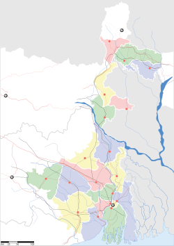
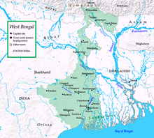
ഇന്ത്യയുടെ കിഴക്കൻതീരത്തുള്ള സംസ്ഥാനമാണ് പശ്ചിമ ബംഗാൾ (പടിഞ്ഞാറൻ ബംഗാൾ ). കൊൽക്കത്തയാണ് തലസ്ഥാനം. ബംഗാൾ ഉൾക്കടൽതീരത്താണ് ഈ സംസ്ഥാനം സ്ഥിതിചെയ്യുന്നത്. സിക്കിം, ആസാം, ഒറീസ്സ, ഝാർഖണ്ഡ്, ബീഹാർ എന്നിവയാണ് ബംഗാളിന്റെ അയൽ സംസ്ഥാനങ്ങൾ. നേപ്പാൾ, ബംഗ്ലാദേശ് എന്നീ രാജ്യങ്ങളുമായി രാജ്യാന്തര അതിർത്തിയും പങ്കിടുന്നു. ബംഗാളി ഭാഷ സംസാരിക്കുന്ന ഭൂപ്രദേശമാണിത്. ഇന്ത്യാ വിഭജനകാലത്ത് ബംഗാളിലെ മുസ്ലീം ഭൂരിപക്ഷ പ്രദേശങ്ങൾ കിഴക്കൻ പാകിസ്താൻ(ഇന്നത്തെ ബംഗ്ലാദേശ്) എന്ന പേരിൽ പാകിസ്താനോടൊപ്പം ചേർത്തു. ഇന്ത്യയിൽ ഒരു കാലത്ത് ഇടതുപക്ഷ രാഷ്ട്രീയകക്ഷികൾക്ക് ശക്തമായ സ്വാധീനമുണ്ടായിരുന്ന സംസ്ഥാനമാണ് ഇത്. കമ്മ്യൂണിസ്റ്റ് പാർട്ടി ഓഫ് ഇന്ത്യ (മാർക്സിസ്റ്റ്) നേതൃത്വം നൽകുന്ന ഇടതുപക്ഷമുന്നണിയാണ് 1977 മുതൽ 2011 വരെ പശ്ചിമ ബംഗാൾ ഭരിച്ചത്[4].
പശ്ചിമ ബംഗാൾ পশ্চিমবঙ্গ | ||
|---|---|---|
| West Bengal | ||
| ||
| Nickname(s): പശ്ചിം | ||
 Location of West Bengal in India | ||
 Map of West Bengal | ||
| രാജ്യം | ഇന്ത്യ | |
| പ്രദേശം | കിഴക്കേ ഇന്ത്യാ | |
| സ്ഥാപിതമായത് | 1 November 1956 | |
| തലസ്ഥാനം | കൊൽക്കത്ത | |
| ഏറ്റവും വലിയ നഗരം ഏറ്റവും വലിയ മെട്രോ | കൊൽക്കത്ത | |
| ജില്ലകൾ | 19 ആകെ | |
| • ഭരണസമിതി | പശ്ചിമ ബംഗാൾ സർക്കാർ | |
| • ഗവർണ്ണർ name ആനന്ദ ബോസ് | [[]] | |
| • മുഖ്യമന്ത്രി | മമത ബാനർജി (തൃണമൂൽ കോൺഗ്രസ്) | |
| • നിയമസഭ | പശ്ചിമ ബംഗാൾ നിയമസഭ (295* സീറ്റുകൾ) | |
| • ഹൈക്കോടതി | കൽക്കട്ട ഹൈക്കോടതി | |
| • ആകെ | 88,752 ച.കി.മീ.(34,267 ച മൈ) | |
| •റാങ്ക് | 13th | |
(2011)[1] | ||
| • ആകെ | 9,13,47,736 | |
| • റാങ്ക് | 4th | |
| • ജനസാന്ദ്രത | 1,000/ച.കി.മീ.(2,700/ച മൈ) | |
| സമയമേഖല | UTC+05:30 (IST) | |
| ISO കോഡ് | IN-WB | |
| HDI | ||
| HDI rank | 19th (2005) | |
| Literacy | 77.08%[2] | |
| ഔദ്യോഗിക ഭാഷകൾ | ബംഗാളി, ഇംഗ്ലീഷ്, നേപ്പാളി[3] | |
| വെബ്സൈറ്റ് | westbengal.gov.in | |
| ^* 294 elected, 1 nominated | ||

അവലംബം
തിരുത്തുക- ↑ "Area, population, decennial growth rate and density for 2001 and 2011 at a glance for West Bengal and the districts: provisional population totals paper 1 of 2011: West Bengal". Registrar General & Census Commissioner, India. Retrieved 26 January 2012.
- ↑ "Sex ratio, 0–6 age population, literates and literacy rate by sex for 2001 and 2011 at a glance for West Bengal and the districts: provisional population totals paper 1 of 2011: West Bengal". Government of India:Ministry of Home Affairs. Retrieved 29 January 2012.
- ↑ "Report of the Commissioner for linguistic minorities: 47th report (July 2008 to June 2010)" (PDF). Commissioner for Linguistic Minorities, Ministry of Minority Affairs, Government of India. pp. 122–126 {Nepali is the official language in three subdivisions of Darjeeling district.}. Retrieved 16 February 2012.
- ↑ "കവർസ്റ്റോറി". മാധ്യമം ആഴ്ചപ്പതിപ്പ് ലക്കം 693. 2011 ജൂൺ 06. Retrieved 2013 മാർച്ച് 18.
{{cite news}}: Check date values in:|accessdate=and|date=(help)