ഒക്ലാഹോമ സിറ്റി, ഒക്ലാഹോമ
ഒക്ലാഹോമാ സിറ്റി, യു.എസ് സംസ്ഥാനാമായ ഒക്ലാഹോമയുടെ തലസ്ഥാനവും സംസ്ഥാനത്തെ ഏറ്റവും വലിയ പട്ടണവുമാണ്. ഇത് ഒക്ലാഹോമ കൌണ്ടിയുടെ കൌണ്ടി സീറ്റും കൂടിയാണ്. ജനസംഖ്യയനുസരിച്ച് ഒക്ലാഹോമാ സിറ്റി യു.എസിലെ 27 ആമത്തെ വലിയ പട്ടണമാണ്. പട്ടണത്തിലെ ജനസംഖ്യ 2010 ലെ സെൻസസ് പ്രകാരം 631,346 ആണ്. 2015 ലെ കണക്കുകളനുസരിച്ച് ഒക്ലാഹോമ സിറ്റി മെട്രോപോളിറ്റൻ മേഖലയിലെ ആകെ ജനസംഖ്യ 1,358,452 ആണ്.
Oklahoma City, Oklahoma | |||
|---|---|---|---|
| City of Oklahoma City | |||
 From top left to clockwise: Downtown skyline, SkyDance Pedestrian Bridge, City Hall, Gold Star Memorial Building, Chesapeake Energy Arena, Oklahoma City National Memorial, state capitol. | |||
| |||
| Nickname(s): | |||
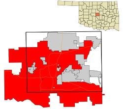
 Location in Oklahoma County and the state of Oklahoma. | |||
| Country | United States | ||
| State | Oklahoma | ||
| Counties | Oklahoma Canadian, Cleveland | ||
| Founded | April 22, 1889[4] | ||
| Incorporated | July 15, 1890[4] | ||
| • Mayor | Mick Cornett (R) | ||
| • City manager | James D. Couch | ||
| • City | 620.34 ച മൈ (1,606.67 ച.കി.മീ.) | ||
| • ഭൂമി | 601.11 ച മൈ (1,556.87 ച.കി.മീ.) | ||
| • ജലം | 19.23 ച മൈ (49.81 ച.കി.മീ.) | ||
| • നഗരം | 410.6 ച മൈ (1,063.5 ച.കി.മീ.) | ||
| ഉയരം | 1,201 അടി (366 മീ) | ||
| • City | 5,79,999 | ||
| • കണക്ക് (2015)[6] | 6,31,346 | ||
| • റാങ്ക് | US: 27th | ||
| • ജനസാന്ദ്രത | 930/ച മൈ (360/ച.കി.മീ.) | ||
| • നഗരപ്രദേശം | 861,505 (US: 51st) | ||
| • മെട്രോപ്രദേശം | 1,459,758 (US: 42nd) | ||
| സമയമേഖല | UTC−6 (CST) | ||
| • Summer (DST) | UTC−5 (CDT) | ||
| ZIP codes | Zip codes[7] | ||
| Area code | 405 | ||
| FIPS code | 40-55000 | ||
| GNIS feature ID | 1102140[8] | ||
| വെബ്സൈറ്റ് | City of Oklahoma City | ||
ഇതും കാണുക
തിരുത്തുകഅവലംബം
തിരുത്തുക- ↑ NewsOK.com. Retrieved February 21, 2008.
- ↑ U.S. City Monikers, Tagline Guru website, accessed January 5, 2008
- ↑ "'Big Friendly' moniker is beginning to stick". NewsOK.com.
- ↑ 4.0 4.1 "Oklahoma City". Oklahoma History Society. Archived from the original on 2016-04-12. Retrieved April 12, 2016.
- ↑ "American FactFinder". United States Census Bureau. Retrieved ഓഗസ്റ്റ് 29, 2014.
- ↑ "Population Estimates". United States Census Bureau. Retrieved മേയ് 26, 2016.
- ↑ "Zip Code Lookup". USPS. Archived from the original on 2010-11-23. Retrieved December 11, 2008.
- ↑ "US Board on Geographic Names". United States Geological Survey. ഒക്ടോബർ 25, 2007. Retrieved ജനുവരി 31, 2008.
പുറം കണ്ണികൾ
തിരുത്തുകWikimedia Commons has media related to Oklahoma City.
- Official city website
- Oklahoma City tourism information
- Convention & Visitors' Bureau
- City-Data page
- Oklahoma City Historic Film Row District website Archived 2018-03-11 at the Wayback Machine.
- New York Times travel article about Oklahoma City
- OKC.NET cultural commentary about Oklahoma City
- Voices of Oklahoma interview with Ron Norick, mayor during the Oklahoma City bombing